
YELLOWMAPS
YellowMaps Sanford NC topo map, 1:24000 Scale, 7.5 X 7.5 Minute, Historical, 1980, Updated 1983, 26.7 x 21.7 in - Polypropylene
AED 795.34
AED 1,325.57
Save 40% (AED 530.23)
-
 Order within 2 hours and 39 minutes to get between May 20 - May 26
 -
 Tracked Shipping on All Orders
-
 14-Day Returns
- Secure Payments
-
 24/7 Customer Support
Description
- Printed on Polypropylene (plastic)
- USGS topographic map of Sanford, NC, at 1:24000 scale. Heavier material. Waterproof. Tear-resistant. Foldable. Perfect for the outdoors.
- Cities, towns, villages: San-Lee Park,Sunset Terrace,Country Lane Estates,Owls Nest,Westcroft,Meadow Park,Berkley Place,Brookhaven,Planters Ridge,Colonial Acres,Brentwood,Lemon Springs,Cool Springs,Trails End,Clearwater Forest,Hanover Circle,Quail Ridge,West Lake Valley,Woodbridge,Kendall Acres,Parkwood Estates,Courtland Acres,Carbonton Heights,Brookwood,Longview Acres,McCracken Heights,Royal Oaks,Saint Andrews,Sanford,Western Hills,Jonesboro Heights,Tramway
- Islands: Consult topo map preview for visible islands.
- Parks and forests: National Parks, National Forests, etc. Please preview map image for specifics.
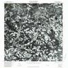
USGS topographic map of Sanford, North Carolina, dated 1980, updated 1983.
Includes geographic coordinates (latitude and longitude), lines of elevation, bodies of water, roads, and more. This topo quad is suitable for recreational, outdoor uses, office applications, or wall map framing.
Printed on-demand by YellowMaps on the print material of your choice.
Shipping rolled from Minneapolis, MN, United States.
Product Number: USGS-5373134
Map Size: 26.7 inches high x 21.7 inches wide
Map Scale: 1:24000
Map Type: POD USGS Topographic Map
Map Series: HTMC
Map Version: Historical
Cell ID: 39851
Scan ID: 164859
Imprint Year: 1983
Aerial Photo Year: 1980
Datum: NAD27
Map Projection: Lambert Conformal Conic
Orthophoto: Quad
Map published by United States Geological Survey
Keywords: Nonstandard Press Run
Map Language: English
Scanner Resolution: 600 dpi
Map Cell Name: Sanford
Grid size: 7.5 X 7.5 Minute
Date on map: 1980
Geographical region: North Carolina, United States
Northern map edge Latitude: 35.5
Southern map edge Latitude: 35.375
Western map edge Longitude: -79.25
Eastern map edge Longitude: -79.125
Surrounding map sheets (copy & paste the Product No. in the search bar):
North: USGS-5369770,USGS-5369772
East: USGS-5369292,USGS-5369288,USGS-5369290
South: USGS-5372180,USGS-5372182
West: USGS-5374088
Shipping and Returns
- We offer tracked shipping on all orders. Tracking information will be shared as soon as the order is dispatched.
- Please check the delivery estimate before adding a product to the cart. This is displayed for every product on the website.
- Available shipping methods and charges will be displayed at the time of checkout, depending on your exact location.
- All customers are entitled to a return window of 14 days, starting from the date of delivery of the product(s).
- Customers are advised to read our return policy for details of the return process, eligibility, refunds as well as cancellations or exchanges.
- In case of any issues or concerns about Shipping or Returns, please contact us and we will be happy to help.
YellowMaps.
YellowMaps Sanford NC topo map, 1:24000 Scale, 7.5 X 7.5 ...
AED 795.34
AED 1,325.57
Save 40.0% (AED 530.23)