
YELLOWMAPS
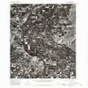
YellowMaps Payette ID topo map, 1:24000 Scale, 7.5 X 7.5 Minute, Historical, 1974, Updated 1975, 27 x 22 in - Polypropylene
AED 795.34
AED 1,325.57
Save 40% (AED 530.23)
-
 Order within 2 hours and 46 minutes to get between May 20 - May 26
 -
 Tracked Shipping on All Orders
-
 14-Day Returns
- Secure Payments
-
 24/7 Customer Support
Description
- Printed on Polypropylene (plastic)
- USGS topographic map of Payette, ID, at 1:24000 scale. Heavier material. Waterproof. Tear-resistant. Foldable. Perfect for the outdoors.
- Cities, towns, villages: Ramey,Payette,Payette Heights,Eiffie,Fruitland,Ingard,Gayway Corner,Washoe,Ontario
- Islands: Pool Island,Little Banks Island,Banks Island,Johnson Island,Duncan Island,Ontario Island,Welch Island
- Parks and forests: Treasure Valley Ball Park,Rosedale Memorial Park,Beck-Kiwanis Park,Eastside Park,Lions Park,Kiwanis Park,Central Park,Ontario State Park,Laxson Park
Shipping and Returns
- We offer tracked shipping on all orders. Tracking information will be shared as soon as the order is dispatched.
- Please check the delivery estimate before adding a product to the cart. This is displayed for every product on the website.
- Available shipping methods and charges will be displayed at the time of checkout, depending on your exact location.
- All customers are entitled to a return window of 14 days, starting from the date of delivery of the product(s).
- Customers are advised to read our return policy for details of the return process, eligibility, refunds as well as cancellations or exchanges.
- In case of any issues or concerns about Shipping or Returns, please contact us and we will be happy to help.
YellowMaps.
YellowMaps Payette ID topo map, 1:24000 Scale, 7.5 X 7.5 ...
AED 795.34
AED 1,325.57
Save 40.0% (AED 530.23)