
YELLOWMAPS
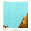
YellowMaps Carrington Island SW UT topo map, 1:24000 Scale, 7.5 X 7.5 Minute, Historical, 1968, Updated 1972, 26.8 x 22 in - Polypropylene
AED 795.34
AED 1,325.57
Save 40% (AED 530.23)
-
 Order within 2 hours and 53 minutes to get between May 20 - May 26
 -
 Tracked Shipping on All Orders
-
 14-Day Returns
- Secure Payments
-
 24/7 Customer Support
Description
- Printed on Polypropylene (plastic)
- USGS topographic map of Carrington Island SW, UT, at 1:24000 scale. Heavier material. Waterproof. Tear-resistant. Foldable. Perfect for the outdoors.
- Cities, towns, villages: Please see map preview to find populated places, townships, as well as roads and street names if available.
- Islands: Consult topo map preview for visible islands.
- Parks and forests: National Parks, National Forests, etc. Please preview map image for specifics.
USGS topographic map of Carrington Island SW, Utah, dated 1968, updated 1972.
Includes geographic coordinates (latitude and longitude), lines of elevation, bodies of water, roads, and more. This topo quad is suitable for recreational, outdoor uses, office applications, or wall map framing.
Printed on-demand by YellowMaps on the print material of your choice.
Shipping rolled from Minneapolis, MN, United States.
Product Number: USGS-5456137
Map Size: 26.8 inches high x 22 inches wide
Map Scale: 1:24000
Map Type: POD USGS Topographic Map
Map Series: HTMC
Map Version: Historical
Cell ID: 69559
Scan ID: 248454
Imprint Year: 1972
Aerial Photo Year: 1969
Field Check Year: 1968
Datum: NAD27
Map Projection: Polyconic
Orthophoto: Map
Map published by United States Geological Survey
Map Language: English
Scanner Resolution: 600 dpi
Map Cell Name: Carrington Island SW
Grid size: 7.5 X 7.5 Minute
Date on map: 1968
Geographical region: Utah, United States
Northern map edge Latitude: 41.125
Southern map edge Latitude: 41
Western map edge Longitude: -112.75
Eastern map edge Longitude: -112.625
Surrounding map sheets (copy & paste the Product No. in the search bar):
North: USGS-5456133,USGS-5456135
East: USGS-5456141,USGS-5456143
South: USGS-5455465
West: USGS-5456653,USGS-5456655
Shipping and Returns
- We offer tracked shipping on all orders. Tracking information will be shared as soon as the order is dispatched.
- Please check the delivery estimate before adding a product to the cart. This is displayed for every product on the website.
- Available shipping methods and charges will be displayed at the time of checkout, depending on your exact location.
- All customers are entitled to a return window of 14 days, starting from the date of delivery of the product(s).
- Customers are advised to read our return policy for details of the return process, eligibility, refunds as well as cancellations or exchanges.
- In case of any issues or concerns about Shipping or Returns, please contact us and we will be happy to help.
YellowMaps.
YellowMaps Carrington Island SW UT topo map, 1:24000 Scal...
AED 795.34
AED 1,325.57
Save 40.0% (AED 530.23)