
MAPREPRODUCTIONS
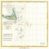
1849 U.S. Coast Survey Map of Nantucket and the Davis Shoals. Preliminary Sketch Showing the positions of Davis's South Shoal and Other Dangers Recently Discovered by the Coast Survey and the sounding on the Old South Shoal, Bass Rip, Old Man, Pochic
AED 244.43
AED 407.38
Save 40% (AED 162.95)
-
 Order within 2 hours and 42 minutes to get between May 20 - May 26
 -
 Tracked Shipping on All Orders
-
 14-Day Returns
- Secure Payments
-
 24/7 Customer Support
Description
This is a modern reprint. This beautiful and important sea chart or map depicts the waters immediately surrounding the island of Nantucket, Massachusetts, including Davis Shoal, Old South Shoal, and others. Uncommon, highly significant, and often under appreciated, this is 1849 map is the one of the first U.S. Coast Survey chart to depict the shoals off Nantucket. Though the unpredictable waters off Nantucket were long a nemesis to sailing vessels on the important London New York shipping routes, they had never been properly charted. The harsh conditions, including rapid unexpected swells and frequent heavy fog, contrived to make the hydrographic survey of the hazards south of Nantucket one of the most dangerous and challenging projects of the early coast survey. floating stations by buoys. The first severe storm not only stops the actual sounding work, but is apt to break up the system entirely by removing or changing the position of these marks. The weather fit for surveying on that peculiarly stormy part of the coast is but a small fragment of each summer, and the harbors which must necessarily be sought as a refuge on the coming up of storms, which cannot be weathered in such exposed situations, are distant.. From Wikimedia CommonsShipping and Returns
- We offer tracked shipping on all orders. Tracking information will be shared as soon as the order is dispatched.
- Please check the delivery estimate before adding a product to the cart. This is displayed for every product on the website.
- Available shipping methods and charges will be displayed at the time of checkout, depending on your exact location.
- All customers are entitled to a return window of 14 days, starting from the date of delivery of the product(s).
- Customers are advised to read our return policy for details of the return process, eligibility, refunds as well as cancellations or exchanges.
- In case of any issues or concerns about Shipping or Returns, please contact us and we will be happy to help.
Mapreproductions.
1849 U.S. Coast Survey Map of Nantucket and the Davis Sho...
AED 244.43
AED 407.38
Save 40.0% (AED 162.95)